The fastest route into professional drone mapping is easy to describe and harder to master. First you get certified to fly by Transport Canada. Then you learn to turn overlapping aerial photos into accurate maps, 3D models, and survey deliverables. A good drone mapping course Canada covers both halves in one place, so you leave able to plan a mission, capture clean data, and hand a client an orthomosaic they will pay for. This guide walks through what that path looks like and how to choose the training that fits your goal.
Mapping is one of the most useful skills a commercial pilot can hold. Construction firms, surveyors, farmers, and aggregate operators all need accurate site data, and many of them would rather hire a trained pilot than buy the gear and learn it themselves. That demand is why drone mapping has become a real career path, and why pairing your flying credential with hands-on mapping training pays off. If your goal is paid work, look at how commercial drone services are actually delivered, then build the skills to match.
What a Drone Mapping Course Canada Actually Teaches
People often picture mapping as flying a drone in straight lines. The flying is the easy part. A drone mapping course Canada should spend most of its time on the workflow around the flight. That means mission planning, image overlap, ground control, and the photogrammetry software that stitches everything together.
A solid curriculum covers:
- Flight planning: setting a grid pattern with roughly 75% front overlap and 65% side overlap so the software has enough matching points.
- Ground control points: placing and measuring marked targets so your map lines up with real-world coordinates.
- Data capture: managing altitude, lighting, and battery swaps across a site that may take several flights.
- Processing: using tools like Pix4D, DroneDeploy, or Agisoft Metashape to build orthomosaics, digital surface models, point clouds, and contour lines.
- Deliverables: measuring distances, areas, and stockpile volumes a client can act on.
By the end, you should be able to fly a 40-hectare site, process the images, and explain the accuracy of what you produced. That last part matters more than most beginners expect.
Get Your Transport Canada Certificate First
You cannot fly a mapping mission for money without the right pilot certificate. Any drone between 250 grams and 25 kilograms falls under Transport Canada’s Remotely Piloted Aircraft System (RPAS) rules. You register the aircraft, and you pass an exam to earn a certificate. The official process is laid out on the Transport Canada drone safety site, and any honest drone mapping course Canada will build its training around those exact requirements.
There are two certificate levels, and the one you need depends on where and how you fly.
Basic or Advanced for Mapping Work?
The Basic certificate lets you fly in uncontrolled airspace, away from bystanders. The exam is 35 questions and you need 65% to pass. It is a fine starting point, but most real mapping jobs push past its limits.
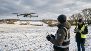
Mapping sites are often near roads, people, or controlled airspace close to an airport. That puts you into Advanced operations, which requires the 50-question Small Advanced exam at 80% to pass, plus an in-person flight review with a certified flight reviewer. If you are serious about paid work, plan for the advanced RPAS certification from the start. SkyTech runs in-person ground school, hands-on flight training, and has certified Flight Reviewers on staff who can administer the flight review directly.
What to Look For in a Drone Mapping Course Canada
Not every program is built the same. When you compare any drone mapping course Canada offers, weigh these factors before you pay.
- Real flight time: hands-on hours with an actual mapping drone beat slides every time. Ask how many hours you fly.
- Software access: you should process a real dataset yourself, not just watch someone else do it.
- Instructor credentials: learn from people who hold the Advanced certificate and fly commercially.
- Flight review on site: a school with its own Flight Reviewers saves you from booking a separate test elsewhere.
- Current equipment: training on gear like DJI Enterprise mapping drones matches what you will use on the job.
One honest warning. A course will not make you a licensed land surveyor. Survey-grade accuracy still depends on proper ground control or RTK, an understanding of coordinate datums, and field experience. A good course gets you producing reliable maps. The legal stamp of a survey is a separate profession with its own licensing.
The Skills You Build Behind the Software
The gear keeps getting easier to fly. A current DJI Enterprise aircraft can plan and run a mapping grid almost on its own, and you can review that hardware on DJI’s enterprise site. So what are you really paying to learn? Judgment.
You learn how weather and sun angle can ruin a dataset. You learn why 60 ground control points are overkill and 3 are too few. You learn the difference between relative accuracy, which most drones hit easily, and absolute accuracy, which can drift by several meters without ground control or RTK correction. With RTK, a careful operator can reach 1 to 2 centimeter accuracy. Without it, you might be off by 1 to 3 meters and not even know. Knowing which one a client actually needs is the skill that earns repeat work.
Where Drone Mapping Can Take Your Career
Mapping opens doors across several industries. Construction crews use drone maps to track progress and measure earthworks. Surveyors cover ground faster. Farmers scout crop health. Mining and aggregate sites measure stockpile volumes that used to take a crew days on foot. A single pilot can map a 100-acre site in a few hours, and that time savings is the whole pitch to a client.
Many graduates of a drone mapping course Canada start by subcontracting to firms that have clients but no pilot. Others add mapping to an existing trade like surveying or building inspection. A smaller group builds an independent service business. All three are realistic, and all three start from the same certified, trained foundation.
How to Choose Your Drone Mapping Course Canada
Start with your goal. If you only want a credential to fly legally, the Basic certificate alone may be enough. If you want paid mapping work, you need the Advanced certificate plus genuine mapping practice, and that is where a full drone mapping course Canada earns its cost.
Match the program to where you want to end up. Ask about flight hours, software, instructor experience, and whether the school can run your flight review in house. A program that handles the training and the flight review together removes the biggest scheduling headache new pilots face. When you are ready to compare options or map out a plan, you can book a free consultation and get a straight answer about the path that fits you.
Drone mapping is a learnable, in-demand skill, and the route is clearer than most people assume. Get certified, take a hands-on drone mapping course Canada that puts a real drone and real data in front of you, and practice until your maps are something you would sign your name to. Do that, and you move from hobby flying to work that pays.
Ready to Take the Next Step?
Whether you need drone pilot certification, a custom engineered solution, help navigating Transport Canada permits, or a professional drone service for your next project, Mostavio-SkyTech is your trusted partner in Canada.
Contact us today for a free consultation and let’s build something great together.